The city of Bristol is well-known in the popular consciousness as an eighteenth- and nineteenth- century port city with close connections to the transatlantic slave trade. It is well-known, too, for its eclectic architectures. Imposing Georgian and Regency buildings sit alongside brutalist structures which serve as a reminder of the city’s extensive post-war rebuild.
These aspects of Bristol’s past are well worthy of our attention, but sometimes they can serve to obscure the city’s previous role as one of the most important urban developments of medieval Britain. The likes of Bristol Cathedral, St Mary Redcliffe Church and the ruined remains of Bristol Castle are important landmarks, but they are merely the tip of the iceberg. Bristol was, in fact, a place of enormous commercial, political, religious, and military significance, as well as being an outward-facing and multicultural border town and staging post for Wales, Ireland and beyond.
The Making Bristol Medieval project seeks to bring Bristol’s older histories to the fore, with the aim of better communicating how the city came to be what it is today. Cultural historians, archaeologists and local historians are working together to find new ways of articulating and promoting Bristol’s palimpsestic and networked pasts.
The project is funded by the Research and Enterprise Knowledge Exchange fund at the University of Bristol.
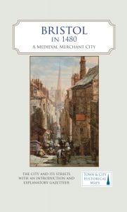
Bristol in 1480: A Medieval Merchant City
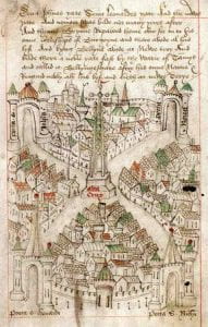
 From August to September 1480, William Worcestre, the former secretary to Sir John Fastolf, visited Bristol. Whilst there, he paced the city’s streets, making meticulous notes on the length, breadth and height of streets, lanes, defensive structures, churches, ditches, hospitals and bridges, as well as recording some of his encounters with locals. It is the first survey of its kind in England, and it offers us an unparalleled insight into how the city would have looked 500 years ago.
The first major output of the Making Bristol Medieval project is a large-scale, full-colour, fold-out map of Bristol as it was at the time of Worcestre’s visit. Using Worcestre’s notes, in conjunction with other documentary and archaeological evidence, the map displays the street layout and buildings of the medieval city against the background of a 1920s Ordnance Survey map. On the reverse of the map, a gazetteer lists the major points of interest, along with brief descriptions and images of key sites.
The map will be printed by the Historic Towns Trust, which has produced similar maps of several historic English cities. It will be published in Autumn 2020.
More information about this and other projects can be found on the Historic Towns Trust website.
Events
Please check back here for news on forthcoming project events.
Team
- PI: Professor Helen Fulton, Professor of Medieval Literature, University of Bristol
- John Bryant, Project Consultant
- Giles Darkes, Cartographer, Historic Towns Trust
- Professor Peter Fleming, Emeritus Professor of History, UWE
- Robert Harding, Project Consultant
- Peter Insole, Principal Historic Environment Officer, Bristol City Council
- Robert Jones, former Archaeologist, Bristol City Council
- Professor Roger Leech, Emeritus Professor of Archaeology, University of Southampton
- Dr Beth Whalley, Research Assistant
![]()
![]()