I’m delighted to have been awarded a small grant from the Being Human Festival to run a public event during the 2023 Festival, which runs from 9–18 November 2023.
‘Finding Medieval Bristol’ is an entertaining and interactive walking tour for families and visitors to Bristol, based on the map of ‘Bristol in 1480: A Medieval Merchant City‘, researched by me and a team of experts and published by the Historic Towns Trust. The themed walk will be led by the theatre company, ‘Show of Strength’, and will feature actors recreating the city as it would have been experienced in 1480 by William Worcestre, whose description of the city in that year was the inspiration for the historical map.
The aim of the Being Human Festival is to celebrate the contribution that research in Arts and Humanities makes to everyday life. I hope that ‘Finding Medieval Bristol’ and its underlying research will increase understanding and appreciation of the city of Bristol and encourage a sense of community belonging.
For further information, contact Helen Fulton, helen.fulton@bristol.ac.uk
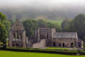
The Cistercian Valle Crucis Abbey near Llangollen.
A five-year research project to explore the history and literature of the medieval March of Wales began on 1 May 2023, based at the University of Bristol. The project is called ‘The Medieval March of Wales, c. 1282–1550: Mapping Literary Geography in a British Border Region’, known as MOWLIT for short.
The project aims to create the first cultural history of the medieval March of Wales, the borderlands between Wales and England, occupied by a diverse population of Welsh, English and French speakers in the period between 1282 and 1550. The main objectives are to uncover and analyse the literary texts and manuscripts produced and circulated in the medieval March, and to create an original series of digital maps of the Marcher lordships at various date points during the period. The texts and the maps will be linked by means of a prosopography, a visualisation of the major gentry houses and abbeys, and a distribution of the texts/manuscripts across the maps showing where they were produced and who read/owned them. These resources will enable an assessment of the cultural and regional identities of the March and its relations with its more powerful neighbour, England.
The project team includes heritage and mapping specialists from the Royal Commission of Ancient and Historic Monuments in Wales and digital humanities specialists from Research IT at the University of Bristol. The project will employ two full-time postdoctoral research assistants and an administrator, and will support a PhD studentship. Outcomes from the project include a monograph, two edited collections, digital and printed maps, and a PhD thesis suitable for publication. You can read more about the project at the MOWLIT website which we have recently set up and which will be added to with new materials at regular intervals.
The project was originally awarded funding through the ERC Advanced Grant scheme and is now funded through the UKRI guarantee.
We aim to engage with local history groups, museums, creative practitioners and other stakeholders with an interest in the region of the March and its history. Please get in touch if you would like to be added to the mailing list to be kept up to date with the project and its activities.
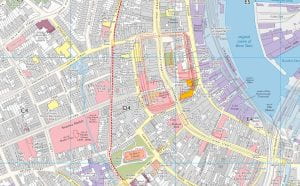
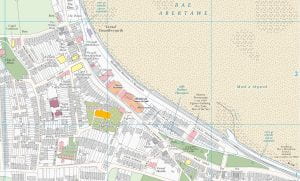
The Historic Towns Trust published the Historic Maps of Swansea and the Mumbles / Mapiau Hanesyddol Abertawe a’r Mwmbwls in April 2023. The two maps, one in English and one in Welsh, were launched at Swansea Museum on 20 May 2023.
The maps show the whole of the central Swansea city area, together with maps of the industrial valley and of the village of Mumbles to the west of the city. The streetscape of medieval Swansea can be seen alongside later developments during Swansea’s heyday as a busy industrial centre from the eighteenth up to the beginning of the twentieth century.
The English map was edited by Helen Fulton and Giles Darkes (Historic Towns Trust) and the Welsh map was edited by Helen Fulton, Giles Darkes, and Geraint Evans (Swansea University). The maps were funded by grants from the University of Bristol and Swansea University, with additional donations from the Gower Society and a number of individuals. The research assistant on the project was Dr Ben Curtis.
The Welsh map is the first of its kind – a map in Welsh of a Welsh town – and the Historic Towns Trust hopes to publish more such bilingual maps. The maps can be purchased through any physical or online bookshop such as Waterstones.
These images show (left) a snapshot of central Swansea from the English map, and (right) a snapshot of the Mumbles from the Welsh map. For further enquiries, contact Helen.fulton@bristol.ac.uk