The Historic Towns Trust published the Historic Maps of Swansea and the Mumbles / Mapiau Hanesyddol Abertawe a’r Mwmbwls in April 2023. The two maps, one in English and one in Welsh, were launched at Swansea Museum on 20 May 2023.
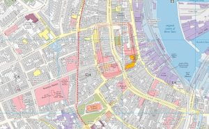
The maps show the whole of the central Swansea city area, together with maps of the industrial valley and of the village of Mumbles to the west of the city. The streetscape of medieval Swansea can be seen alongside later developments during Swansea’s heyday as a busy industrial centre from the eighteenth up to the beginning of the twentieth century.
The English map was edited by Helen Fulton and Giles Darkes (Historic Towns Trust) and the Welsh map was edited by Helen Fulton, Giles Darkes, and Geraint Evans (Swansea University). The maps were funded by grants from the University of Bristol and Swansea University, with additional donations from the Gower Society and a number of individuals. The research assistant on the project was Dr Ben Curtis.
The Welsh map is the first of its kind – a map in Welsh of a Welsh town – and the Historic Towns Trust hopes to publish more such bilingual maps. The maps can be purchased through any physical or online bookshop such as Waterstones.
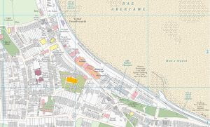
These images show (left) a snapshot of central Swansea from the English map, and (right) a snapshot of the Mumbles from the Welsh map. For further enquiries, contact Helen.fulton@bristol.ac.uk